UTM Zone Map Viewer
Last updated on: 27-01-2026 and Estimated reading time: 9minutes
UTM Zone Map – Understanding the UTM Coordinate System
Navigating the globe requires precision, and one of the most accurate and widely-used systems for mapping and geolocation is the UTM coordinate system. A UTM zone map divides the Earth into a series of zones that make it easier to represent geographic locations with exactitude. Whether you're a cartographer, surveyor, geographer, or simply an enthusiast, understanding UTM zones can be incredibly valuable.
What is the UTM Coordinate System?
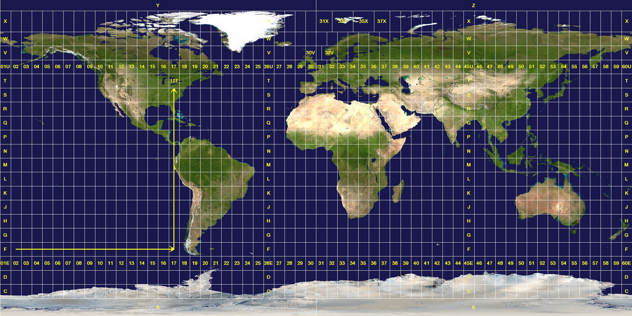
The Universal Transverse Mercator (UTM) coordinate system is a global map projection that uses a 2D Cartesian coordinate system to give locations on the surface of the Earth. Unlike latitude and longitude, which use spherical coordinates, UTM breaks the world into 60 vertical zones, each 6 degrees of longitude in width The zones are numbered 1-60, beginning at 180-degrees longitude and increasing to the east. this A single grid zone measures aprox 660km wide.
Each UTM zone is projected separately, minimizing distortion and allowing for high accuracy. The UTM system is based on the WGS 1984 datum, making it a cornerstone for GPS-based mapping.
UTM Zone Map Overview
A UTM zone map visually displays how Earth is divided into these 60 zones, ranging from Zone 1 at 180°W to Zone 60 at 180°E. Each zone spans from 80°S to 84°N latitude. Zones are further subdivided horizontally into bands, labeled from “C” to “X” (excluding "I" and "O"), forming what’s known as the UTM grid map.
These divisions are essential for:
Military operations
Surveying
Navigation systems
Engineering and environmental projects
Interactive UTM Grid Map
Modern mapping tools now offer dynamic UTM grid maps, allowing users to explore specific UTM zones with precision. By clicking on any location, users can view UTM zone values, central meridian, and bounding coordinates. Tools like Leaflet.js provide interactive maps where you can overlay a UTM coordinate map and retrieve real-time UTM zone data with ease.
Benefits of Using a UTM Coordinate Map
Accuracy: Minimizes distortion within each zone
Simplicity: Uses meters for measurement, making it user-friendly for engineers and developers
Global Standard: Based on the UTM WGS 1984 zone map, ensuring compatibility with GPS and global mapping services
Compatibility: Widely used in GIS, CAD, and GPS systems
Applications of the UTM Zone System
Urban Planning: For infrastructure layout and design
Environmental Monitoring: To track deforestation, pollution, and natural resource management
Search and Rescue: Providing precise location information

A global UTM Zone Map showing division into 60 zones from Zone 1 to Zone 60 (Source: Wikipedia)
Important Countries and Their UTM Zones
| Country | UTM Zone(s) | Notes |
|---|---|---|
| United States | 10N to 19N | From California to Maine |
| Canada | 7N to 22N | Western to Eastern provinces |
| India | 42N to 46N | Most of India spans these zones |
| China | 45N to 51N | Large east-west spread |
| Russia | 32N to 60N | Spans 11 time zones |
| Brazil | 18S to 25S | In the Southern Hemisphere |
| Australia | 49S to 57S | Across Western to Eastern Australia |
| Germany | 32N to 33N | Mainly in Zone 32N and 33N |
| United Kingdom | 30N | Entire UK fits in Zone 30N |
| France | 31N to 32N | Western and Eastern France |
| South Africa | 33S to 36S | Southern Hemisphere zones |
| Japan | 51N to 54N | Multiple islands across zones |
| Mexico | 11N to 16N | North to southeast spread |
| Indonesia | 46S to 54S | Large east-west island chain |
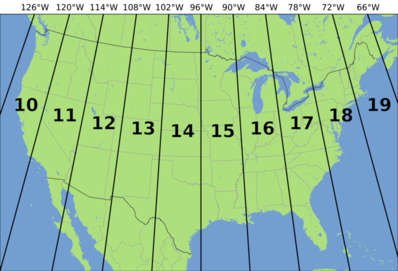
How UTM Zones Work in the USA
The United States spans multiple UTM zones, ranging from Zone 10 on the West Coast to Zone 19 in the East. These zones help accurately map geographic locations using the Universal Transverse Mercator (UTM) coordinate system. Below is a quick overview of the major UTM zone in the USA:
- UTM Zone 10 – Covers the western regions of California, Oregon, and Washington.
- UTM Zone 11 – Includes Nevada, Utah, and parts of Arizona and Idaho.
- UTM Zone 12 – Spans Colorado, Wyoming, and parts of New Mexico and Montana.
- UTM Zone 13 – Covers most of Texas, parts of Oklahoma, Kansas, and Nebraska.
- UTM Zone 14 – Includes regions of Minnesota, Iowa, Missouri, and Arkansas.
- UTM Zone 15 – Encompasses areas of the Great Lakes, including Wisconsin, Illinois, and Indiana.
- UTM Zone 16 – Covers Michigan, Ohio, and parts of the southeastern U.S.
- UTM Zone 17 – Includes states like Georgia, South Carolina, and parts of Florida.
- UTM Zone 18 – Covers North Carolina, Virginia, Maryland, and parts of Pennsylvania.
- UTM Zone 19 – Includes parts of New York, New England, and coastal northeastern states.

Source: Wikipedia, EPSG.io, Leaflet.js, OpenStreetMap, U.S. Geological Survey
Frequently Asked Questions (FAQ)
A UTM zone is one of 60 longitudinal strips the Earth is divided into, each 6 degrees wide, under the Universal Transverse Mercator coordinate system. These zones are used to provide highly accurate, meter-based location references for GPS, mapping, and geospatial applications. Each zone has its own coordinate grid to minimize distortion.
You can find your UTM zone using our app. Simply allow location access, and the map will display your current UTM zone. You can also click anywhere on the map to find the UTM zone for that specific location.
Unlike latitude and longitude, which are angular and difficult to calculate distances with, UTM uses a Cartesian coordinate system measured in meters. This makes calculations faster and more accurate—ideal for engineers, surveyors, developers, and anyone working on infrastructure, land use, or GPS-based navigation..
There are 60 UTM zones globally, each covering 6 degrees of longitude and extending from 80°S to 84°N. These zones are further divided by latitude into horizontal bands, forming a global grid. Countries like Russia, the USA, and China span multiple UTM zones, while smaller nations may fall entirely within one.
UTM zones are labeled with a hemisphere—North (N) or South (S)—to distinguish location. The equator is the dividing line: zones in the Northern Hemisphere are labeled with an "N" (e.g., 43N for India), and those in the Southern Hemisphere with an "S" (e.g., 25S for Brazil). This distinction ensures accurate calculations across the globe.
Download UTM Grid Map Files
MapInfo (.tab)
Download MapinfoGeoJSON (.geojson)
Download GeojsonShapefile (.shp)
Download ShapefileKML (.kml)
Download KML
About the Author
I'm Narendra Kumar, an RF and geospatial engineer with over 15 years of experience. I specialize in RF planning and network optimization, particularly in LTE and GSM technologies, having worked with industry leaders like Ericsson, Bharti Airtel, and Huawei.
I bridge the gap between spatial systems and telecom performance, using tools like Atoll, and enjoy sharing my insights through web projects on UTM coordinate systems and GPS mapping.