What Is My Current Elevation?
Your current elevation is the height of your location above mean sea level. You can instantly check your elevation using GPS or by selecting any point on the interactive map. Our free Current Elevation Finder provides fast and accurate altitude data worldwide in meters and feet.
📍 Your Current Elevation
Your elevation is the height of your location above sea level. Click "Find My Elevation" to instantly check your current elevation using GPS.
Current Location
Recent Locations


What Is My Current Elevation?
The elevation of a geographic location is its height above or below a fixed reference point—most commonly mean sea level. Elevation is typically expressed in feet or meters and is a vital data point for hikers, travelers, scientists, and everyday users curious about their surroundings.
You can instantly check your current elevation using your device’s location permission, or click anywhere on the map to find the elevation of any location in the world.
What Is Elevation?
Elevation describes the height of a place on Earth above sea level. It is used for land locations such as cities, mountains, valleys, and hills.
📊 Understanding elevation vs altitude visually:
Example: My Current Elevation
Current Location: Denver, Colorado, United States
My Current Elevation: Approximately 1,609 meters (5,280 feet) above sea level
Elevation vs. Altitude vs. Depth
Elevation: Height above sea level (land).
Altitude: Height of an object in the air (aircraft).
Depth: Distance below surface (water).
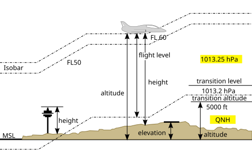
Diagram showing elevation (ground height), altitude (aircraft height), and sea level reference.
📍 Check Your Current Location Elevation
To find your elevation automatically:
- Click the “Find my elevation” button.
- Allow location permission when your browser asks.
- Your elevation will appear instantly on map.
🔐 Location Permission Required
For accurate results, your browser needs permission to access your location. We only use your location to calculate elevation — nothing is stored or shared.
🗺️ Find Elevation by Clicking on the Map
You can also check the elevation of any place in the world.
- Zoom in to your desired area on the map.
- Click on any point.
- Instantly see the elevation of that location including of Lat/long.
This feature is useful for:
- Hikers and trekkers
- Construction planning
- Weather research
- Travel and exploration
🗺️ Click on the Map to Find Elevation
You can easily find the elevation of any location by clicking directly on the map. Just zoom in, tap on a point, and the elevation will appear instantly.
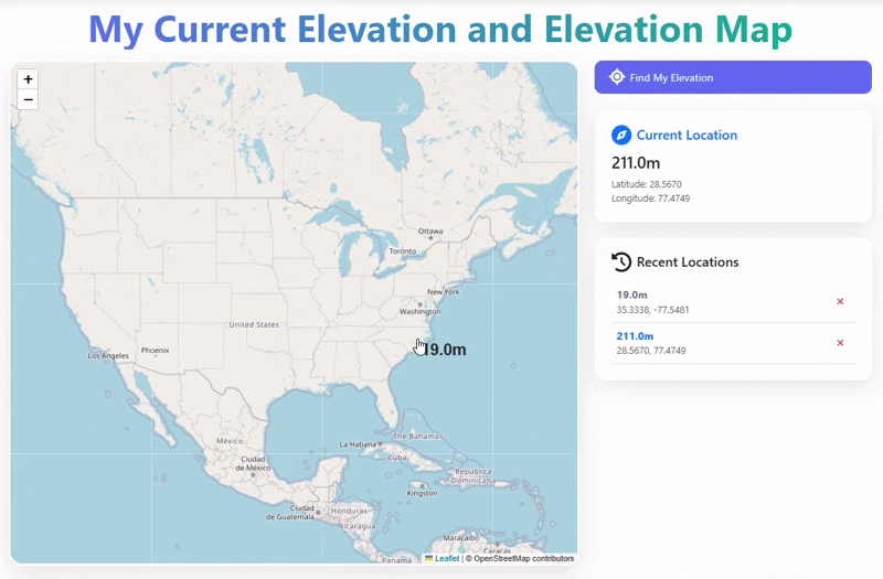
Example: Clicking anywhere on the map instantly displays elevation in meters and feet.
Elevation vs Altitude vs Depth
| Term | Meaning | Used For |
|---|---|---|
| Elevation | Height above sea level | Land locations |
| Altitude | Height in air | Aircraft |
| Depth | Below surface level | Water bodies |
How High Above Sea Level Am I Right Now?
Your elevation above sea level shows how high your current location is compared to the Earth's average sea level. This tool uses GPS coordinates to calculate your exact height above sea level instantly.
Check Elevation Near Me
You can quickly find your current elevation near you using our free tool. Whether you are at home, traveling, or hiking, this tool shows your exact height above sea level in real-time.
Current Elevation of My Location
Your current location elevation is calculated using GPS coordinates and global elevation data. Simply allow location access and get accurate altitude instantly.
Why This Elevation Tool Is Better
⭐ Check my elevation now or click anywhere on the map to find elevation worldwide.
- ✔ Check my elevation now using GPS
- ✔ Click anywhere on the map to find elevation instantly
- ✔ Works worldwide (any country or location)
- ✔ Shows elevation in meters and feet
👉 Tip: Click anywhere on the map to explore elevation instantly!
FAQ on Current Elevation
Elevation refers to the height of a point or location above a specific reference point, commonly above sea level. It is usually expressed in meters or feet.
Elevation is typically measured using instruments such as altimeters, GPS devices, or topographic maps. These tools can provide accurate readings of a location's height.
Elevation is crucial for various reasons, including weather patterns, climate, agriculture, and construction. It affects temperature, air pressure, and even the types of vegetation that can thrive in an area.
Elevation refers to the height of a point above sea level, while altitude generally refers to the height of an object or point in the air, often used in aviation contexts.
The highest elevation point on Earth is the summit of Mount Everest, which stands at approximately 29,032 feet (8,848 meters) above sea level.
People Also Ask
How do I check my elevation on my phone?
Click “Find My Elevation” and allow location access.
Is GPS elevation accurate?
GPS elevation is usually accurate within a few meters.
What is normal elevation?
Elevation varies by location; there is no fixed normal value.
Did You Know?
🧗♂️ Mount Everest is the highest point on Earth at 8,848.86 meters (29,031.7 feet) above sea level — that’s nearly the cruising altitude of a jet!
🏝️ The Dead Sea, located between Jordan and Israel, is the lowest land elevation on Earth at -430 meters (-1,411 feet) below sea level.